
Study(Refer to FAA-CT-8080-2H, Figure 20, area 3.) With ATC authorization, you are operating your small unmanned aircraft approximately 4 SM southeast of Elizabeth City Regional Airport (ECG). What hazard is indicated to be in that area?
- ❌A:High density military operations in the vicinity.
- ❌B:Unmarked balloon on a cable up to 3,008 feet AGL.
- ✅C:Unmarked balloon on a cable up to 3,008 feet MSL.
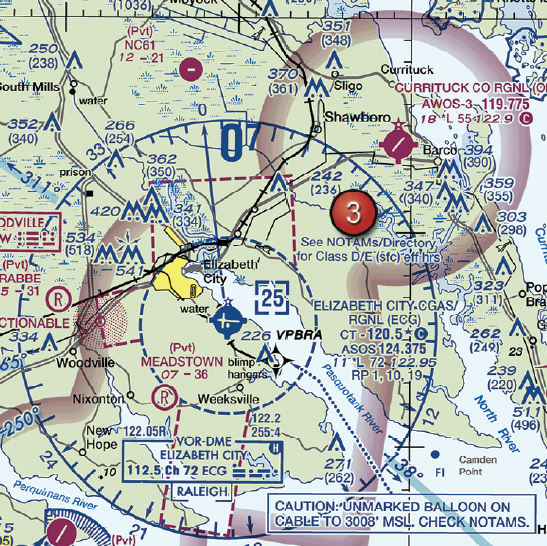
FAA-CT-8080-2H Figure 20 Area 3 - Click to enlarge.
Answer Figure
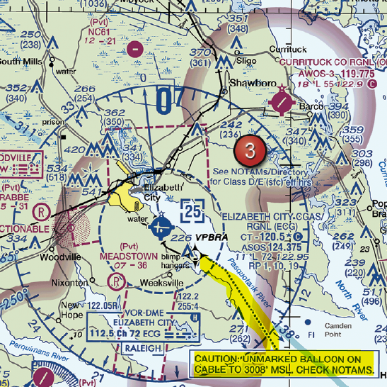
Click to enlarge answer figure
Explanations
- A: This choice is incorrect because there are no charted military operations in this area. Misinterpretation of sectional charts can lead to safety risks and operational inefficiencies, negatively affecting your business.
- B: This choice is incorrect because the altitude reference given is in MSL (Mean Sea Level), not AGL (Above Ground Level). Misunderstanding altitude references can lead to potential collisions and subsequent business liability.
- C: This choice is correct. The sectional chart shows a caution box indicating a tethered balloon hazard up to 3,008 feet MSL. Awareness of such hazards is critical for safe operations and maintaining a positive reputation for your drone business.
🧭 Instructor Note
Why This Matters for Your Business
Understanding sectional charts and accurately interpreting hazards is crucial for your drone business. It ensures safe operations, reduces the risk of costly accidents, and helps maintain a positive reputation with clients and regulatory authorities.
Safety & Liability Considerations
Misinterpreting a sectional chart can lead to safety risks such as potential collisions with hazards like tethered balloons. Such incidents can result in significant damage, injury, and subsequent business liability.
Consider This Scenario
A real estate company hires a drone operator to capture aerial footage of a property near Elizabeth City Regional Airport. The operator, with ATC authorization, misinterprets the sectional chart and fails to identify a tethered balloon hazard. The drone collides with the balloon cable, causing damage to the drone and disruption to the balloon operations. The operator's business reputation suffers, and they face potential liability for the incident.
What the FAA is Testing
The FAA is testing your ability to interpret sectional charts accurately, specifically your understanding of hazard indications and altitude references (MSL vs. AGL).
Business Success Strategy
Ensure you and your team are proficient in reading and interpreting sectional charts. Regularly review chart symbols and altitude references. Before each operation, thoroughly scan the sectional chart for fixed hazards. This will enhance safety, efficiency, and client satisfaction.
Memory Aid
Be sure to check markings carefully. MSL or AGL? Confirm MSL/AGL. Usually "in the air" measurements will be MSL (above the oceans) and "from the ground" heights, etc. will be AGL. The drone is "AGL" because we're looking from the ground, but the balloon is "MSL" because it's a danger in the air.
Enhanced References
FAA Aeronautical Chart User's Guide, ACS UA.V.B.K6a, Business Case: Drone Collision with Balloon Cable.
Related Concepts
- Interpreting sectional charts accurately
- Understanding MSL and AGL altitude references
- Importance of obstacle awareness in drone operations
ACS Code: UA.V.B.K6a
Difficulty: intermediate