
FAA(Refer to FAA-CT-8080-2H, Figure 59, area 2.) The chart shows a gray line with 'VR1667, VR1617, VR1638, and VR1668.' Could this area present a hazard to the operations of a small UA?
- ❌A:No, all operations will be above 400 feet.
- ✅B:Yes, this is a Military Training Route from the surface to 1,500 feet AGL.
- ❌C:Yes, the defined route provides traffic separation to manned aircraft.
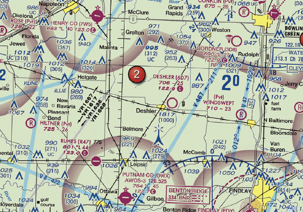
FAA-CT-8080-2H Figure 59 Area 2 - Click to enlarge.
Answer Figure
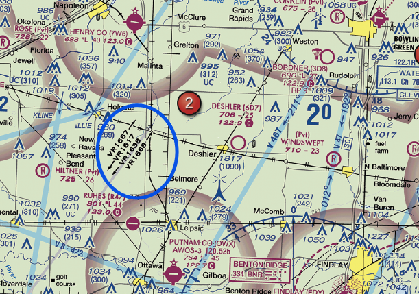
Click to enlarge answer figure
Explanations
- A: This choice is incorrect because it assumes that all drone operations will be above 400 feet. However, Military Training Routes (MTRs) can include high-speed, low-level military traffic at or below 1,500 feet AGL, which is within the typical operating altitudes of small unmanned aircraft systems (sUAS). Ignoring these routes could lead to safety hazards, including potential collisions, and regulatory violations.
- B: This is the correct answer. The VR routes indicated on the chart are Military Training Routes that extend from the surface up to 1,500 feet AGL. Operating a drone in these areas without proper coordination can pose a significant risk of collision with high-speed military aircraft. This could lead to serious safety incidents, potential regulatory violations, and significant business disruptions.
- C: This choice is incorrect because it incorrectly assumes that these routes provide traffic separation for manned aircraft. In reality, these are Visual Flight Rules (VFR) routes with no Air Traffic Control (ATC) separation services. Manned aircraft can fly at high speeds along these routes without necessarily communicating their presence, posing a potential hazard to drone operations.
🧭 Instructor Note
Why This Matters for Your Business
Understanding Military Training Routes (MTRs) and their potential hazards is crucial for any drone business. Operating a drone near these routes without proper coordination can lead to serious safety incidents, including potential collisions with high-speed military aircraft. These incidents can result in regulatory violations and significant business disruptions, affecting your reputation and bottom line.
Safety & Liability Considerations
The primary safety concern with MTRs is the risk of collision with high-speed, low-level military aircraft. These aircraft may not be communicating their presence, increasing the risk for drone operators. Any safety incident can also lead to potential regulatory violations, with consequences ranging from fines to the suspension of your Remote Pilot Certificate.
Consider This Scenario
A drone inspection company is contracted to inspect power lines in a rural area. The operator notices a gray line marked 'VR1667' on the sectional chart. Ignoring this, the operator flies the drone along the power lines. Suddenly, a high-speed military aircraft flies past at low altitude, narrowly missing the drone. This near-miss incident leads to an FAA investigation, potential fines, and a damaged reputation for the company.
What the FAA is Testing
The FAA wants to ensure that drone operators understand the significance of MTRs and the potential hazards they pose. The FAA also wants to test your knowledge of the rules and regulations regarding drone operations near these routes.
Business Success Strategy
Always check sectional charts for MTRs before planning a drone operation. If your operation is near an MTR, coordinate with the appropriate military facility or ATC. This proactive approach can help you avoid safety incidents and regulatory violations, protecting your business and reputation.
Memory Aid
Remember, MTRs are like "Military Speedways" – high-speed, low-level routes for military aircraft. Just like you wouldn't drive a bicycle on a highway, you should avoid flying your drone near these routes without proper coordination. 4-digit MTRs start at ground level.
Enhanced References
FAA Aeronautical Chart User's Guide, Section on Military Training Routes; FAA Advisory Circular AC 91-57B, Section on Operating Near MTRs.
Related Concepts
- Military Training Routes (MTRs)
- Airspace hazard avoidance
- Visual Flight Rules (VFR)
- Air Traffic Control (ATC) separation services
ACS Code: UA.II.A.K2
Difficulty: intermediate