
FAA(Refer to FAA-CT-8080-2H, Figure 26.) What does the line of latitude at area 4 measure?
- ❌A:The degrees of latitude east and west of the Prime Meridian.
- ✅B:The degrees of latitude north and south of the equator.
- ❌C:The degrees of latitude east and west of the line that passes through Greenwich, England.
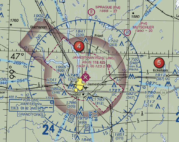
FAA-CT-8080-2H Figure 26 Area 4 - Click to enlarge.
Answer Figure
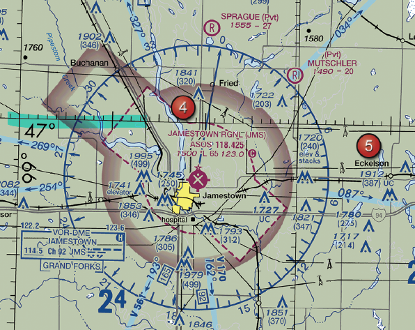
Click to enlarge answer figure
Explanations
- A: Incorrect. Latitude measures the degrees north and south of the equator, not east and west of the Prime Meridian. Misunderstanding this could lead to navigation errors, potentially causing safety risks and operational inefficiencies in your drone business.
- B: Correct. Latitude lines indicate the degrees north and south of the equator. Understanding this is crucial for accurate navigation, which is essential for safety, regulatory compliance, and efficient business operations.
- C: Incorrect. The degrees east and west of the line that passes through Greenwich, England, describe longitude, not latitude. Misinterpreting this could lead to navigation errors, posing safety risks and potential inefficiencies in your drone operations.
🧭 Instructor Note
Why This Matters for Your Business
Understanding latitude and longitude is fundamental for accurate navigation during drone operations. Misinterpretations can lead to navigation errors, which can pose safety risks and operational inefficiencies. For businesses offering services such as aerial surveying, inspections, or deliveries, precise navigation is crucial for delivering quality services and maintaining profitability.
Safety & Liability Considerations
Incorrect navigation can lead to safety risks, including collision with obstacles or other aircraft, and potential damage or injury. It can also lead to regulatory violations if the drone inadvertently enters restricted airspace due to navigation errors. Both safety incidents and regulatory violations can have significant liability implications for your business.
Consider This Scenario
A drone service provider is contracted to conduct an aerial survey of a large agricultural field. The client provides the latitude and longitude coordinates for the field. Misinterpreting the coordinates could lead the operator to the wrong location, wasting time and resources, and potentially causing safety incidents or regulatory violations. Understanding the difference between latitude and longitude and accurately interpreting them on sectional charts is crucial for the success of such operations.
What the FAA is Testing
The FAA is testing your understanding of basic geographical concepts, specifically latitude, and how they are represented on sectional charts. These concepts are fundamental for accurate navigation, which is critical for safe and efficient drone operations.
Business Success Strategy
Ensure all drone operators in your business understand the concepts of latitude and longitude and can accurately interpret them on sectional charts. Regularly review and practice these skills to maintain proficiency. Use digital tools and resources to aid in navigation and flight planning.
Memory Aid
Latitude is the Flat-itude lines, the flat lines running around the earth. They measure distance north or south from the equator.
Enhanced References
FAA Aeronautical Chart User's Guide, Sectional Aeronautical Charts, ACS UA.V.B.K6a
Related Concepts
- Latitude vs. longitude
- Reading sectional charts
- Geospatial awareness
ACS Code: UA.V.B.K6a
Difficulty: basic